Bandar Lengeh County
Bandar Lengeh County
Persian: شهرستان بندر لنگه | |
|---|---|
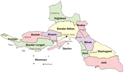 Location of Bandar Lengeh County in Hormozgan province (left, green) | |
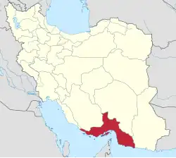 Location of Hormozgan province in Iran | |
| Coordinates: 26°32′N 54°31′E / 26.533°N 54.517°E[1] | |
| Country | Iran |
| Province | Hormozgan |
| Capital | Bandar Lengeh |
| Districts | Central, Kish, Mehran, Shibkaveh |
| Area | |
• Total | 7,617 km2 (2,941 sq mi) |
| Population (2016)[2] | |
• Total | 159,358 |
| • Density | 21/km2 (54/sq mi) |
| Time zone | UTC+3:30 (IRST) |
Bandar Lengeh County (Persian: شهرستان بندر لنگه) is in Hormozgan province, Iran. Its capital is the city of Bandar Lengeh.[3]
History
After the 2006 National Census, Dezhgan and Mehran Rural Districts were separated from the Central District in the formation of Mehran District.[4] After the 2011 census, the village of Lamazan was elevated to the status of a city.[5]
Demographics
Population
At the time of the 2006 census, the county's population was 113,625 in 24,712 households.[6] The following census in 2011 counted 134,713 people in 32,981 households.[7] The 2016 census measured the population of the county as 159,358 in 44,398 households.[2]
Administrative divisions
Bandar Lengeh County's population history and administrative structure over three consecutive censuses are shown in the following table.
| Administrative Divisions | 2006[6] | 2011[7] | 2016[2] |
|---|---|---|---|
| Central District | 78,368 | 73,583 | 79,125 |
| Dezhgan RD | 7,461 | ||
| Howmeh RD | 9,624 | 10,973 | 12,674 |
| Mehran RD | 8,071 | ||
| Moghuyeh RD | 13,028 | 15,636 | 16,803 |
| Bandar Lengeh (city) | 25,303 | 30,478 | 30,435 |
| Kong (city) | 14,881 | 16,496 | 19,213 |
| Kish District | 21,637 | 25,952 | 41,258 |
| Kish RD | 79 | 86 | 191 |
| Lavan RD | 891 | 1,047 | 1,214 |
| Kish (city) | 20,667 | 24,819 | 39,853 |
| Mehran District | 18,662 | 20,321 | |
| Dezhgan RD | 9,304 | 10,304 | |
| Mehran RD | 9,358 | 7,272 | |
| Lamazan (city) | 2,745 | ||
| Shibkaveh District | 13,620 | 16,516 | 18,645 |
| Bandar Charak RD | 4,435 | 5,118 | 5,765 |
| Moqam RD | 6,227 | 7,640 | 8,814 |
| Bandar Charak (city) | 2,958 | 3,758 | 4,066 |
| Total | 113,625 | 134,713 | 159,358 |
| RD = Rural District | |||
See also
![]() Media related to Bandar Lengeh County at Wikimedia Commons
Media related to Bandar Lengeh County at Wikimedia Commons
References
- ↑ OpenStreetMap contributors (17 November 2024). "Bandar Lengeh County" (Map). OpenStreetMap (in Persian). Retrieved 17 November 2024.
- 1 2 3 Census of the Islamic Republic of Iran, 1395 (2016): Hormozgan Province. amar.org.ir (Report) (in Persian). The Statistical Center of Iran. Archived from the original (Excel) on 5 May 2022. Retrieved 19 December 2022.
- ↑ Habibi, Hassan (c. 2022) [Approved 21 June 1369]. Approval of the organization and chain of citizenship of elements and units of Hormozgan province's national divisions centered in Bandar Abbas city. qavanin.ir (Report) (in Persian). Ministry of the Interior, Defense Political Commission of the Government Council. Proposal 53/5/1/3233; Resolution 93808/T907. Archived from the original on 24 February 2022. Retrieved 9 February 2024 – via Laws and Regulations Portal of the Islamic Republic of Iran.
- ↑ Rahimi, Mohammad Reza (c. 2023) [Approved 25 January 1389]. Formation of Mehran District under the citizenship of Bandar Lengeh County in Hormozgan province. qavanin.ir (Report) (in Persian). Ministry of the Interior, Political and Defense Commission. Proposal 4/42/120274; Letter 158802/T38854H. Archived from the original on 30 August 2023. Retrieved 27 April 2024 – via Laws and Regulations Portal of the Islamic Republic of Iran.
- ↑ Rahimi, Mohammad Reza (c. 2024) [Approved 29 June 1391]. Approval letter regarding the transformation of the villages of Tazian-e Pain, Kuhestak, Tirur and Lamazan into cities. lamtakam.com (Report) (in Persian). Ministry of the Interior, Political and Defense Commission. Proposal 4/1/42/136808; Letter 158802/T38854; Notification 217529/T47736K. Archived from the original on 9 February 2024. Retrieved 9 February 2024 – via Lam ta Kam.
- 1 2 Census of the Islamic Republic of Iran, 1385 (2006): Hormozgan Province. amar.org.ir (Report) (in Persian). The Statistical Center of Iran. Archived from the original (Excel) on 20 September 2011. Retrieved 25 September 2022.
- 1 2 Census of the Islamic Republic of Iran, 1390 (2011): Hormozgan Province. irandataportal.syr.edu (Report) (in Persian). The Statistical Center of Iran. Archived from the original (Excel) on 17 January 2023. Retrieved 19 December 2022 – via Iran Data Portal, Syracuse University.
Hormozgan province, Iran | |||||||||||||||||||||||||
|---|---|---|---|---|---|---|---|---|---|---|---|---|---|---|---|---|---|---|---|---|---|---|---|---|---|
| Capital |
|  | |||||||||||||||||||||||
| Counties and cities |
| ||||||||||||||||||||||||
| Sights |
| ||||||||||||||||||||||||
| populated places |
| ||||||||||||||||||||||||
| See also |
| ||||||||||||||||||||||||