Ardabil County
Ardabil County
Persian: شهرستان اردبیل | |
|---|---|
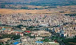 Ardabil skyline | |
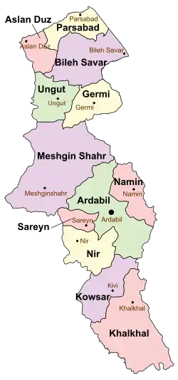 Location of Ardabil County in Ardabil province (center, green) | |
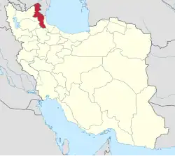 Location of Ardabil province in Iran | |
| Coordinates: 38°17′N 48°19′E / 38.283°N 48.317°E[1] | |
| Country | Iran |
| Province | Ardabil |
| Capital | Ardabil |
| Districts | Central, Hir, Samarin |
| Area | |
• Total | 2,211 km2 (854 sq mi) |
| Elevation | 1,500 m (4,900 ft) |
| Population (2016)[2] | |
• Total | 605,992 |
| • Density | 270/km2 (710/sq mi) |
| Time zone | UTC+3:30 (IRST) |
| Ardabil County at GEOnet Names Server | |
Ardabil County (Persian: شهرستان اردبیل) is in Ardabil province, Iran. Its capital is the city of Ardabil.[3]
History
Sareyn District was separated from the county in the establishment of Sareyn County in 2009.[4] In 2010, Gharbi Rural District was separated from the Central District in the formation of Samarin District, which included the new Dujaq Rural District.[5]
In 2018, the village of Samarin was elevated to the status of a city,[6] and the village of Aralluy-e Bozorg merged with another village to form the new city of Arallu in 2019.[7]
Demographics
Population
At the time of the 2006 National Census, the county's population was 542,930 in 131,950 households.[8] The following census in 2011 counted 564,365 people in 156,242 households.[9] The 2016 census measured the population of the county as 605,992 in 180,975 households.[2]
Administrative divisions
Ardabil County's population history and administrative structure over three consecutive censuses are shown in the following table
| Administrative Divisions | 2006[8] | 2011[9] | 2016[2] |
|---|---|---|---|
| Central District | 502,186 | 533,495 | 578,237 |
| Arshaq-e Sharqi RD | 5,856 | 4,400 | 3,403 |
| Balghelu RD | 21,368 | 7,297 | 8,054 |
| Gharbi RD | 10,730 | ||
| Kalkhuran RD | 13,564 | 9,991 | 10,048 |
| Sardabeh RD | 20,579 | 20,446 | 19,396 |
| Sharqi RD | 17,420 | 8,729 | 7,962 |
| Ardabil (city) | 412,669 | 482,632 | 529,374 |
| Hir District | 23,547 | 21,709 | 19,282 |
| Fuladlui-ye Jonubi RD | 3,148 | 2,619 | 2,021 |
| Fuladlui-ye Shomali RD | 9,263 | 9,423 | 9,341 |
| Hir RD | 8,548 | 7,146 | 5,840 |
| Arallu (city)[a] | |||
| Hir (city) | 2,588 | 2,521 | 2,080 |
| Samarin District | 9,161 | 8,471 | |
| Dujaq RD | 4,186 | 3,535 | |
| Gharbi RD | 4,975 | 4,936 | |
| Samarin (city)[b] | |||
| Sareyn District[c] | 17,197 | ||
| Ab-e Garm RD | 7,844 | ||
| Sabalan RD | 4,875 | ||
| Sareyn (city) | 4,478 | ||
| Total | 542,930 | 564,365 | 605,992 |
| RD = Rural District | |||
See also
![]() Media related to Ardabil County at Wikimedia Commons
Media related to Ardabil County at Wikimedia Commons
Notes
- ↑ Formerly Aralluy-e Bozorg; became a city after the 2016 census[7]
- ↑ Became a city after the 2016 census[6]
- ↑ Transferred to Sareyn County[4]
References
- ↑ OpenStreetMap contributors (18 August 2024). "Ardabil County" (Map). OpenStreetMap (in Persian). Retrieved 18 August 2024.
- 1 2 3 Census of the Islamic Republic of Iran, 1395 (2016): Ardabil Province. amar.org.ir (Report) (in Persian). The Statistical Center of Iran. Archived from the original (Excel) on 22 March 2019. Retrieved 19 December 2022.
- ↑ Habibi, Hassan (c. 2021) [Approved 21 June 1369]. Approval of the organization and chain of citizenship of the elements and units of the national divisions of East Azerbaijan province, centered in the city of Tabriz. qavanin.ir (Report) (in Persian). Ministry of the Interior, Defense Political Commission of the Government Council. Resolution 93808/T907. Archived from the original on 23 October 2021. Retrieved 21 February 2024 – via Laws and Regulations Portal of the Islamic Republic of Iran.
- 1 2 Davodi, Parviz (c. 2024) [Approved 3 March 1388]. Approval regarding national divisions in Ardabil province. lamtakam.com (Report) (in Persian). Ministry of the Interior, Council of Ministers. Proposal 91539/42/1/1; Notification 81794/T41085H. Archived from the original on 18 January 2025. Retrieved 18 January 2025 – via Lam ta Kam.
- ↑ "The government approved: Seven changes in the map of Ardabil and Isfahan national divisions". dolat.ir (in Persian). Ministry of the Interior, Political and Defense Commission of the Government Board. 18 February 2010. Archived from the original on 26 March 2017. Retrieved 28 November 2023 – via Secretariat of the Government Information Council.
- 1 2 "Ardabil: The pristine nature of Samarin according to the picture". tasnimnews.com (in Persian). Ministry of the Interior, Board of Ministers. 28 May 2018 [Approved March 2018]. Archived from the original on 28 November 2023. Retrieved 28 November 2023 – via Tasnim News Agency.
- 1 2 Jahangiri, Ishaq (15 August 2019) [Approved 23 April 1398]. Approval regarding national divisions in Ardabil province. sdil.ac.ir (Report) (in Persian). Ministry of the Interior, Cabinet of Ministers. Proposal 213334; Notification 48644/T56309AH. Archived from the original on 22 March 2023. Retrieved 30 January 2025 – via Shahr Danesh Legal Research Institute.
- 1 2 Census of the Islamic Republic of Iran, 1385 (2006): Ardabil Province. amar.org.ir (Report) (in Persian). The Statistical Center of Iran. Archived from the original (Excel) on 20 September 2011. Retrieved 25 September 2022.
- 1 2 Census of the Islamic Republic of Iran, 1390 (2011): Ardabil Province. irandataportal.syr.edu (Report) (in Persian). The Statistical Center of Iran. Archived from the original (Excel) on 15 January 2023. Retrieved 19 December 2022 – via Iran Data Portal, Syracuse University.
| Capital |  | ||||||||||||||||||||||
|---|---|---|---|---|---|---|---|---|---|---|---|---|---|---|---|---|---|---|---|---|---|---|---|
| Counties and cities |
| ||||||||||||||||||||||
| Landmarks |
| ||||||||||||||||||||||
| Places |
| ||||||||||||||||||||||
| Capital | |||||||||||||||||||||||||||||||
|---|---|---|---|---|---|---|---|---|---|---|---|---|---|---|---|---|---|---|---|---|---|---|---|---|---|---|---|---|---|---|---|
| Districts |
| ||||||||||||||||||||||||||||||