0

As the title says I need .csv with coordinates of the world's continents. All I can find on the Internet are coordinates of world cities, which is not exactly what I am searching for. I want to make a map like the one attached below. enter image description here Does anyone knows any good source to get such a file?

I will give a map of what I am currently running with.

  1. I have found a .csv file with world countries. The file contains the longitudes and latitudes of those countries.
  2. My JS program gets information about those positions and draws them as small points. I get something like this: enter image description here 
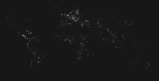
As you can see the contours of the continents such as Africa are barely visible. That's why I am looking for a .csv file with that kind of coordinates.
Day Nam
  • 1
  • 2
  • 1
    What software you want to use to create a map? Does it have to be a CSV? GIS-vector-data normally come in other formats like Shapfile, Geopackage, GeoJSON, KML etc. If using QGIS (opensource GIS), you can simply type world to the coordinates field and you get a simple vector map conatining polygons of all countries worldwide. Dissolve by continent and here you are. Also have a look at https://www.naturalearthdata.com/ – Babel Aug 31 '21 at 20:04
  • I am writing a program using JavaScript and unfortunately, the best way to load and read data (I could be wrong here) is using that data saved as a .csv file. naturalearthdata.com has the things I want, but not in the formats I need. – Day Nam Aug 31 '21 at 20:09
  • OK, but you could convert data from a GIS-vector format using a software like QGIS. If using JavaScript, GeoJSON might be the format you're looking for? – Babel Aug 31 '21 at 20:12
  • Not exactly unfortunately :/ – Day Nam Aug 31 '21 at 20:20
  • Please clarify your specific problem or provide additional details to highlight exactly what you need. As it's currently written, it's hard to tell exactly what you're asking. – Community Aug 31 '21 at 20:21
  • I'm currently facing your same issue and I wonder if you've already found a good way to deal with it. Thanks – spoken_g Jun 14 '22 at 14:32

1 Answers1

1

I think the answer is basically what Babel responded with. You could get the continents dataset online, no problem, in .gpkg, geoJSON (which might be usable by itself in your java code), or .shp file format and convert it to .csv using QGIS.

One note about getting a single landmass outline like the picture above (no country/continent borders) is that you will need to dissolve either A: all the countries' individual polygons from a country dataset or B: all of the continent's polygons from a continent dataset in order to not have border lines between them.