I'm trying to clip two layers in ArcMap. They share spatial features and overlap each other, and they both have the same geographic and projected coordinate systems. It seems like everything should be working, but whenever I run the clip, it generates empty output.
One of these layers ("NMW boundary") was a KMZ file that I converted to a layer. Initially it was a polyline, but after I projected it (initially, it didn't have a projection) it turned into a regular line. I am wondering if maybe that has something to do with my issue, because there isn't anything in the attribute table of the former KMZ file-- but I don't think that should make a difference.
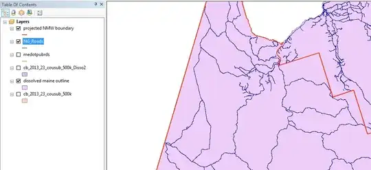
I've attached a picture of the map I'm working on. I'm trying to clip "NG_Roads" to "projected NMW boundary", so that roads only appear within the red outline of "NMW boundary".