These two links were the sources I used when researching this question:
"Mapping critical loads of nitrogen deposition for aquatic ecosystems in the Rocky Mountains"
http://co.water.usgs.gov/publications/non-usgs/Nanus_2012.pdf
"Approaches for estimating critical loads of nitrogen and sulfur deposition for Forest Ecosystems of U.S. Federal Lands"
http://www.nrs.fs.fed.us/pubs/gtr/gtr_nrs71.pdf
It looks like there are actually several different approaches which can be used when calculating the Critical loads, and depending on the approach the factors considered change:
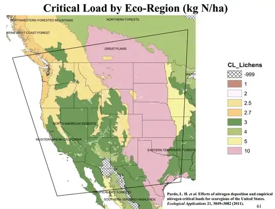
Empirical (Regression) modeling: These are generally based on observations of ecosystem response (this is tracked off of Foliage, lichens, or soils) and tracked to a given deposition level. This is generally calculated in one area, and applied elsewhere.
Simple mass-balance models: estimating a net loss or accumulation of nutrients based in the in/out of a system for that nutrient. These are basically steady state models and are measured generally on base cations or nitrogen.
Dynamic models using a mass balance approach which incorporates internal feedbacks over time. This is a combination of the two and is generally used where there is an abundance of existing data.
The links contain further information which may be more helpful.
According to "Wolfe, A.P., Baron, J.S., Cornett, R., 2001. Anthropogenic nitrogen deposition induces rapid change in alpine lakes of the Colorado Front Range (USA). Journal of Paleolimnology 25, 1e7." as cited in the first article I linked, This excess N (caused by exceeding the critical load) can result in acidification and nutrient enrichment, increasing primary productivity in high-elevation lakes and streams, and altering diatom community structures that form the base of the food web –
The USFWS Ecoregion classification system was designed by Robert G. Bailey working out of the Rocky Mountain Research Station in Colorado. In his paper, "Identifying Ecoregion Boundaries" found Here: http://www.fs.fed.us/rm/ecoregions/docs/publications/identifying-ecoregion-boundaries.pdf he outlines the rational used for identifying the boundaries, and the 20 different principals he used. They are: 1. The series of ecoregions should express the changing nature of the climate over large areas. 2. Boundaries of ecoregions coincide with certain climatic parameters, 3. , 4. , 5 - 20
 !
!