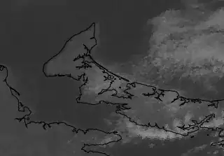
The WMS server of Iowa State is serving data for the GOES-13 satellite in the visible channel. As best as I can tell, the data is misaligned with other data sources. For example, in a WMS client, superimposing Blue Marble data, or any data containing political boundary lines, over on top of the Visible GOES-13 data from Iowa State, results in an apparent misalignment.
The Iowa State data (I think) is displaced about 6 pixels towards the east. You can see it here, towards the middle of the image, where the land comes to a point (North Cape, Prince Edward Island, Canada, 47.06N, -64.00W).
Iowa State re-projects the raw feed from NOAA into EPSG:4326 using something called GDAL. Here is their code:
https://github.com/akrherz/pyWWA/blob/master/gini2gis.py#L160
My questions.
- Can you confirm using your own WMS client that the problem exists, and lies with the Iowa State WMS server?
- From a cursory examination, do you see anything weird in the Iowa State code that does the re-projection?
I have been in contact with Iowa State about the issue, but unfortunately they aren't pursuing it.