Comitatul Olmsted, Minnesota
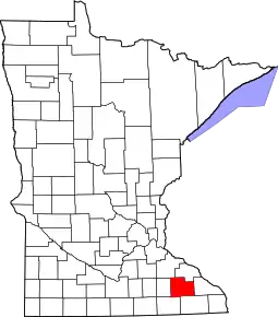
Comitatul Olmsted se află în sud-estul statului Minnesota, Statele Unite ale Americii. Fondat în anul 1855, comitatul ocupă o suprafață de 1,695 km², dintre care 1,691 km² este uscat. Conform datelor furnizate de USCB, la recensământul din 2010, comitatul avea o populație de 144,248 locuitori cu densitatea de 73 loc./km².
| Comitatul Olmsted, Minnesota | |
| Olmsted County | |
| — county of Minnesota[*] — | |
 | |
Comitatul Olmsted, Minnesota (SUA) Poziția geografică în Statele Unite ale Americii | |
| Coordonate: 🌍 | |
|---|---|
| Țară | |
| Stat al SUA | |
| Atestare | |
| Numit după | David Olmsted[*] |
| Reședință | Rochester |
| Suprafață | |
| - Total | 1,695 km² |
| Populație (2020) | |
| - Total | 162.847 locuitori |
| Prezență online | |
| site web oficial OpenStreetMap relation | |
 Poziția localității Comitatul Olmsted, Minnesota | |
Localități
| Orașe | Districte urbane (Townships) | Localități neîncorporate | ||
|---|---|---|---|---|
|
|
|
|
|
Legături externe
| Control de autoritate |
|---|
This article is issued from Wikipedia. The text is licensed under Creative Commons - Attribution - Sharealike. Additional terms may apply for the media files.