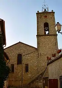
Le Plan-de-la-Tour
Le Plan-de-la-Tour este o comună în departamentul Var din sud-estul Franței. În 2019 avea o populație de 3.048 de locuitori.[2]
| Le Plan-de-la-Tour | |||
| — Comună — | |||
 | |||
| |||
 Le Plan-de-la-Tour Le Plan-de-la-Tour (Franța) | |||
| Coordonate: 🌍 | |||
|---|---|---|---|
| Țară | |||
| Regiune | Provența-Alpi-Coasta de Azur | ||
| Departament | Var | ||
| Suprafață[1] | |||
| - Total | 36,8 km² | ||
| Populație (2009[2]) | |||
| - Total | 11,455 locuitori | ||
| - Densitate | 311,28 loc./km² | ||
| Fus orar | UTC+1 | ||
| Cod poștal | 83120 | ||
| Cod INSEE | 83094 | ||
| Prezență online | |||
| site web oficial OpenStreetMap relation | |||
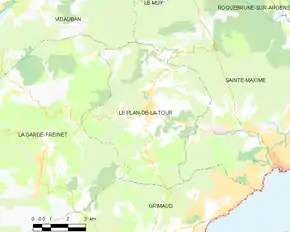 Poziția localității Le Plan-de-la-Tour | |||
_Var-France.svg.png.webp)
Evoluția populației
| An | 1975 | 1982 | 1990 | 1999 | 2006 | 2009 |
|---|---|---|---|---|---|---|
| Populație | 6.938 | 7.900 | 9.704 | 10.975 | 10.603 | 11.455 |
Note
- „Suprafața comunelor din Franța”. Toutes les villes. Accesat în .
- „Populația comunelor din Vaucluse”. Thomas Brinkhoff: City Population. Accesat în .
Vezi și
| Control de autoritate |
|
|---|
This article is issued from Wikipedia. The text is licensed under Creative Commons - Attribution - Sharealike. Additional terms may apply for the media files.