Hounslow (burg)
Hounslow este un burg londonez în sud-vestul Londrei.
| Anul | Pop. | ±% |
|---|---|---|
| 1801 | 11.672 | — |
| 1811 | 13.717 | +17.5% |
| 1821 | 15.861 | +15.6% |
| 1831 | 17.817 | +12.3% |
| 1841 | 20.924 | +17.4% |
| 1851 | 23.095 | +10.4% |
| 1861 | 32.942 | +42.6% |
| 1871 | 42.789 | +29.9% |
| 1881 | 52.637 | +23.0% |
| 1891 | 65.836 | +25.1% |
| 1901 | 85.688 | +30.2% |
| 1911 | 111.565 | +30.2% |
| 1921 | 132.823 | +19.1% |
| 1931 | 158.134 | +19.1% |
| 1941 | 183.060 | +15.8% |
| 1951 | 211.916 | +15.8% |
| 1961 | 209.161 | −1.3% |
| 1971 | 206.469 | −1.3% |
| 1981 | 198.967 | −3.6% |
| 1991 | 209.016 | +5.1% |
| 2001 | 212.344 | +1.6% |
| 2011 | 253.957 | +19.6% |
| Note:[2] | ||
- https://ons.maps.arcgis.com/home/item.html?id=a79de233ad254a6d9f76298e666abb2b Lipsește sau este vid:
|title=(ajutor) - „Hounslow: Total Population”. A Vision of Britain Through Time. Great Britain Historical GIS Project. Accesat în .
| Hounslow | |||
| — burg[*] și unparished area[*] — | |||
 | |||
| |||
Hounslow (Regatul Unit) Poziția geografică în Regatul Unit | |||
| Coordonate: 🌍 | |||
|---|---|---|---|
| Țară | |||
| Regiune | Londra[*] | ||
| Comitat ceremonial | |||
| Atestare | | ||
| Reședință | Hounslow[*] | ||
| Guvernare | |||
| - leader of Hounslow borough council[*] | Steve Curran[*] | ||
| Suprafață[1] | |||
| - Total | 55,9779 km² | ||
| Populație (2018) | |||
| - Total | 270.782 locuitori | ||
| Fus orar | UTC±0 | ||
| Cod poștal | TW | ||
| Prefix telefonic | 020 | ||
| Localități înfrățite | |||
| - Issy-les-Moulineaux | Franța | ||
| - Ramala | Imperiul Otoman | ||
| Prezență online | |||
| site web oficial OpenStreetMap relation | |||
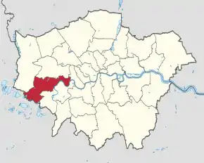 Poziția localității Hounslow | |||

This article is issued from Wikipedia. The text is licensed under Creative Commons - Attribution - Sharealike. Additional terms may apply for the media files.