Vallée d'Aure
| Vallée d'Aure | |
|---|---|
.jpg) | |
| Length | 40 km North |
| Geology | |
| Type | Vallée glaciaire |
| Geography | |
| Location | Hautes-Pyrénées, Midi-Pyrénées, France |
| Population centers | Sarrancolin, Arreau, Ancizan, Guchen, Grézian, Cadéac, Vielle-Aure, Saint-Lary-Soulan, Aragnouet |
| Coordinates | 42°49′48″N 0°19′48″E / 42.8300°N 0.3300°E[1] |
| Mountain range | Pyrénées |
| Traversed by | Neste |
The vallée d'Aure is located in the French Pyrenees, in the Hautes-Pyrénées department, in the region of Midi-Pyrénées.
Geography
The vallée d'Aure is part of the pays d'Aure, of which the historical capital is Arreau.
It corresponds to the upper flow of the Neste or Neste d'Aure. It spans about 40 km from Sarrancolin to the Spanish border, accessible by the Aragnouet-Bielsa tunnel.
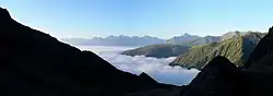
the vallée d'Aure under a sea of clouds
Main communes
- Arreau
- Gouaux
- Sarrancolin
- Bourisp
- Ancizan
- Guchen
- Guchan
- Grézian
- Cadéac
- Cadeilhan-Trachère
- Lançon
- Camparan
- Grailhen
- Bazus-Aure
- Barrancoueu
- Vignec
- Sailhan
- Estensan
- Azet
- Beyrède-Jumet
- Ilhet
- Vielle-Aure
- Saint-Lary-Soulan
- Tramezaïgues
- Aragnouet and the hamlets of Eget, Fabian, Le Plan
- Aspin-Aure
- Pailhac
- Jézeau
Mineralogy
The vallée d'Are has the particularity of disposing of remarkable mineral deposits such as byssolite, tremolite or prehnite.
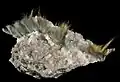 Byssolite
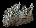 Tremolite
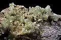 Prehnite
Flora and fauna
The Aure et Saint-Girons ~ or Auroise ~ is a breed of cattle endemic to the valley.
History
Ski resorts
- Saint-Lary-Soulan
- Piau-Engaly
- Nistos (alpine and cross-country skiing)
References
- ↑ Source : Google Maps et Géoportail
This article is issued from Wikipedia. The text is licensed under Creative Commons - Attribution - Sharealike. Additional terms may apply for the media files.