Võhandu
| Võhandu | |
|---|---|
 | |
| Location | |
| Country | Estonia |
| Physical characteristics | |
| Source | |
| • location | near Saverna[1] |
| • coordinates | 58°03′42″N 26°42′58″E / 58.06167°N 26.71611°E |
| • elevation | 132 m (433 ft) |
| Mouth | |
• location | Lake Lämmi[1] |
• coordinates | 58°06′04″N 27°33′16″E / 58.10111°N 27.55444°E |
• elevation | 30 m (98 ft) |
| Length | 162 km (101 mi) |
| Basin size | 1,420 km2 (550 sq mi) |
| Discharge | |
| • average | 5.5–6.0 m3/s (190–210 cu ft/s) |
| Basin features | |
| Progression | Lake Peipus→ Narva→ Gulf of Finland |
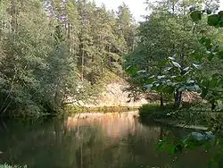
The Võhandu (Estonian: Võhandu) is a river in Estonia.
At 162 km (101 mi), the Võhandu is the longest Estonian river fully in Estonian territory.[1]
In 1963 a protected area was founded in the Võhandu Valley.
Wikimedia Commons has media related to Võhandu River.
References
- 1 2 3 "Võhandu jõgi - Eesti Entsüklopeedia". entsyklopeedia.ee. Retrieved 2 March 2024.
This article is issued from Wikipedia. The text is licensed under Creative Commons - Attribution - Sharealike. Additional terms may apply for the media files.