Salient (geography)
A salient, panhandle, or bootheel is an elongated protrusion of a geopolitical entity, such as a subnational entity or a sovereign state.
While similar to a peninsula in shape, a salient is most often not surrounded by water on three sides. Instead, it has a land border on at least two sides and extends from the larger geographical body of the administrative unit.
In American English, the term panhandle is often used to describe a relatively long and narrow salient, such as the westernmost extensions of Florida and Oklahoma, or the northernmost portion of Idaho. Another term is bootheel, used for the Missouri Bootheel and New Mexico Bootheel areas.
Origin
The term salient is derived from military salients. The term "panhandle" derives from the analogous part of a cooking pan, and its use is generally confined to North America.
The salient shape can be the result of arbitrarily drawn international or subnational boundaries, which serve to separate culturally unified peoples.[1] These occurred, for instance, during European colonialisation when colonial powers competed for Africa and the Western Hemisphere, after which post-colonial borders became based on colonial divisions.[2] In many cases these salients correspond to routes of expansion or bases for such expansion, as in Namibia and Mozambique.[3] Other modern salients originally served to provide barriers against other colonial powers, as with Britain against Tsarist Russia in Central Asia.[1]
Salients may also arise when a national government shifts territory between subnational entities for internal political reasons, as with West Virginia's eastern panhandle during the Civil War.[4] This also occurred with peripheral Tibetan-inhabited regions in Maoist China, which were split between provinces and from the Tibet Autonomous Region.[5]
The location of administrative borders can also take into account other considerations such as economic ties,[6] strategic needs,[7] history or topography. Even in these situations, however, salients frequently fail to follow clear and logical criteria, as seen with the partition of India and the resultant northeastern salient. Upon partition numerous majority-Muslim areas remained within Hindu India, and some non-Muslim-majority areas within the exclave of East Pakistan.[8]
Country-level salients
Africa


| Salient | Country |
|---|---|
| Cibitoke Province | |
| Far North Region | |
| Congo Pedicle | |
| Kongo Central | |
| Southern Red Sea Region | |
| Gambela Region | |
| Somali Region | |
| Nimba County | |
| Nsanje District | |
| Kayes Region | |
| Azawad | |
| Tete Province | |
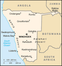
| Caprivi Strip | |
| Casamance | |
| Kalahari Gemsbok National Park | |
| Upper Nile | |
| Blue Nile | |
| Wadi Halfa Salient | |
| Kagera Region | |
| Cinkassé Prefecture |
Asia


| Salient | Country |
|---|---|
| Wakhan Corridor | |
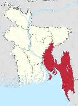
| Chittagong | |
| Rangpur | |
| Sylhet | |
| Western Belait District | |
| Myanmar Panhandle (Kayin State, Mon State and Tanintharyi Region) | |
| Puta-O District | |
| Maungdaw District | |
| Mong Yawng Township | |
| Parrot's Beak | |
| Yadong County (Tibet Autonomous Region) | |
| Seven Sister States (largest and most populous in the world) | |
| Sikkim | |
| West Timor | |
| Jerusalem corridor | |
| Galilee panhandle | |
| Mafraq Governorate | |
| Mangystau Region | |
| Batken | |
| Phongsaly Province | |
| Tfail Salient | |
| North Hamgyŏng, South Hamgyŏng and Ryanggang | |
| Primorsky Krai | |
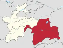
| Sughd | |
| Southern Thailand | |
| Aralık, Iğdır Province | |
| Hatay Province | |
| Tashkent Region | |
| Fergana and Andijan Regions | |
| Namangan | |
| Tashkent City | |
| Jizzakh Region | |
| Sirdaryo Region | |
| Surxondaryo Region | |
| Tây Ninh Province |
Europe

| Salient | Country |
|---|---|
| Syunik | |
| Tyrol and Vorarlberg | |
| West Flanders | |
| Tamashowka | |
| Neum | |
| Dubrovnik-Neretva County | |
| Ilok | |
| Louroujina Salient | |
| Aš administrative district | |
| Šluknov Hook | |
| Laatre, Viljandi County | |
| Enontekiö | |
| Charleville-Mézières | |
| Kakheti | |
| Western Thrace | |
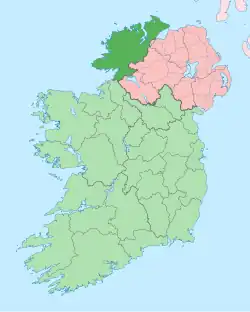
| County Donegal | |
| County Monaghan | |
| Province of Trieste | |
| Dieveniškės appendix | |
| Castelré, North Brabant | |
| Limburg | |
| County Fermanagh | |
| Pasvikdalen valley | |
| Gmina Bogatynia | |
| Kłodzko County | |
| Melgaço and north of Monção and Arcos de Valdevez (Viana do Castelo District) | |
| Tourém in north of Montalegre (Vila Real District) | |
| Miranda do Douro, Mogadouro and Vimioso (Bragança District) | |
| Moura and eastern Barrancos (Beja District) and Mourão (Évora District) | |
| Bryansk Oblast | |
| Ain, (around the border of Switzerland) | |
| Galicia | |
| Slovene Istria | |
| Prekmurje | |
| Canton of Geneva | |
| Canton of Schaffhausen | |
| Bernina, Inn, Lugano, Mendrisio and Porrentruy Districts | |
| Budjak | |
| Jamena | |
| Petsamo | |
| Enontekiö |
South America

| Salient | Country |
|---|---|
| Misiones | |
| Leticia Trapeze | |
| Southeast Guainía Department | |
| Yavaraté, Vaupés Department | |
| Petén Department | |
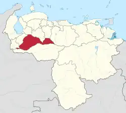
| Tumbes Region | |
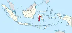
| Amazonas |
North America
| Salient | Country |
|---|---|
| Southeast Alaska | |
| New England | |
| South Texas | |
| Southern Ontario (particularly Ontario Peninsula) | |
| Tatshenshini-Alsek Park, British Columbia | |
| Madawaska County, New Brunswick | |
| Labrador West, Newfoundland and Labrador |
Subnational salients
The following locations are salients in First-level administrative subdivisions of nations.
Africa

| Salient | Country |
|---|---|
| Tafraoui and Oran Province | |
| Southwestern Saïda Province | |
| Northeastern Bié Province | |
| Western Mono Department | |
| Eastern Kgalagadi District | |
| Balé Province and Boucle du Mouhoun Region | |
| Kouritenga Province, Centre-Est Region | |
| Northwest Bujumbura Rural Province | |
| Northern Muyinga Province | |
| Kimongo District, Niari Department | |
| Northwestern Wele-Nzas Province | |
| Sitti Zone, Somali Region | |
| Haut-Komo Department, Woleu-Ntem Province | |
| Upper Denkyira West District, Central Region | |
| Télimélé Prefecture, Kindia Region | |
| Northeast Mamou Prefecture, Mamou Region | |
| Western Isiolo County | |
| Eastern Al Wahat District | |
| Southern Mzimba District, Northern Region | |
| Eastern Dakhlet Nouadhibou Region | |
| Boumdeid Department, Assaba Region | |
| Southeastern Tete Province | |
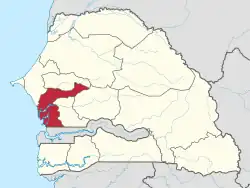
| Gossas Department, Fatick Region | |
| Southern Uvinza District, Kigoma Region | |
| Babati, Hanang, Mbulu Districts, Manyara Region | |
| Gokwe North and Gokwe South Districts, Midlands Province |
South America
.svg.png)
| Salient | Country |
|---|---|
| Southern Buenos Aires Province | |
| Luis Calvo, Chuquisaca Department | |
| Sud Cinti, Chuquisaca Department | |
| Whale Coast, Bahia | |
| Alto Parnaíba, Balsas, and Tasso Fragoso, southernmost Maranhão | |
| Northern Mato Grosso | |
| Ponta do Abunã in northwest Rondônia | |
| Triângulo Mineiro, Minas Gerais | |
| Arauco Province, Bío Bío Region | |
| San Antonio Province, Valparaíso Region | |
| Urabá region, Antioquia Department | |
| Unguía and Acandí in northernmost Chocó Department | |
| Santander Department northern tip | |
| Santa Rosa and Piamonte in southeastern Cauca Department | |
| Cotacachi Canton, Imbabura Province | |
| Eastern Tena Canton, Napo Province | |
| Balzar and El Empalme Cantons, Guayas Province | |
| Northern East Berbice-Corentyne | |
| Caravelí Province, Arequipa Region | |
| Northern Tapanahony, Sipaliwini District | |
| Páez, Apure | |
| Western Andrés Eloy Blanco Municipality, Barinas | |
| Arismendi Municipality, Barinas |
North and Central America
| Salient | Country |
|---|---|
| Toronto (East York, Etobicoke, Old Toronto, York) | |
| Northwestern British Columbia | |
| Middle Côte-Nord, Quebec | |
| Western Puntarenas Province | |
| Guamá, Santiago de Cuba Province | |
| Southern Hato Mayor Province | |
| Southern Samaná Province | |
| Southern San Miguel Department | |
| Norte, Jalisco | |
| Eastern Tabasco | |
| Southeastern Zacatecas | |
| Southern Zacatecas | |
| Chiriquí Grande District, Bocas del Toro Province | |
| Southern Chimán District, Panamá Province | |
| Mariato District, Veraguas Province | |
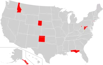
| Alaska | |
| Connecticut | |
| Florida[a] | |
| Idaho | |
| Maryland[b] | |
| Nebraska | |
| Oklahoma | |
| Texas | |
| Eastern West Virginia | |
| Missouri Bootheel | |
| Northern West Virginia | |
| New Mexico Bootheel | |
| Trans-Pecos | |
| The Thumb |
Asia
| Salient | Country |
|---|---|
| Wakhan District, Badakhshan Province | |
| Nawa District, Ghazni Province | |
| Chishti Sharif District, Herat Province | |
| Eastern Sarpang District | |
| Tianchang, Anhui | |
| Maqu County, Gansu | |
| Fan County and Taiqian County, Henan | |
| Pingliang and Qingyang, Gansu | |
| Daxing'anling Prefecture, Heilongjiang | |
| Zhaotong, Yunnan | |
| Koraput and Malkangiri districts, Odisha | |
| Pathankot district, Punjab | |
| Kota division, Rajasthan | |
| Southern Jhansi division, Uttar Pradesh | |
| Wonogiri Regency, Central Java | |
| Pacitan Regency, East Java | |
| Mahakam Ulu Regency, East Kalimantan | |
| South Jakarta, Jakarta Special Capital Region, and Depok, West Java | |
| Tabalong Regency, South Kalimantan | |
| East Luwu Regency, South Sulawesi | |
| Ogan Komering Ilir Regency, South Sumatra | |
| Pasaman Regency, West Sumatra | |
| Semirom County, Isfahan Province | |
| Southwest Razavi Khorasan Province | |
| Southern Yazd Province | |
| Noda, Chiba | |
| Nose, Osaka | |
| Ōra District, Gunma | |
| Reinan(Wakasa), Fukui | |
| Wadi Araba Department, Aqaba Governorate | |
| Russeifa Department, Zarqa Governorate | |
| Southwest Panfilov District, Chuy Region | |
| Chong-Alay District, Osh Region | |
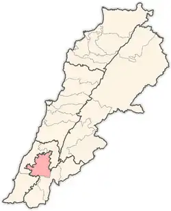
| Nabatieh District, Nabatieh Governorate | |
| Bandar Baharu District, Kedah, | |
| Northeast of Kuantan District, Eastern Pahang | |
| South of Kemaman District, Terengganu | |
| Gangaw Township, Magway Region | |
| Thabeikkyin District, Mandalay Region | |
| Eastern Achham District, Far-Western Region | |
| Western Surkhet District, Mid-Western Region | |
| Bannu, Karak, and Kohat Divisions, Khyber Pakhtunkhwa, | |
| Tiwi, Albay | |
| Northernmost portion of barangay San Isidro, Cainta, Rizal[9] | |
| Northwestern Cagayan | |
| Libis/Reparo, Santa Quiteria and Talipapa of southern Caloocan | |
| Carmona, Cavite | |
| Northeastern Ilocos Sur (roughly corresponding to its 1st district), | |
| Barangays Casile and Pittland, Cabuyao, Laguna | |
| Santa Maria, Laguna | |
| Las Piñas (Almanza Dos) | |
| Eastern Maguindanao del Sur, Philippines (municipalities east of Sultan sa Barongis) | |
| Carranglan, Nueva Ecija | |
| Alfonso Castañeda, southern Dupax del Norte and Dupax del Sur, Nueva Vizcaya | |
| Eastern Sultan Kudarat (roughly corresponding to its 1st district, excluding Isulan) | |
| Zakamensky, Tunkinsky and Okinsky Districts, Buryatia | |
| Katangsky District, Irkutsk Oblast | |
| Kirensky, Mamsko-Chuysky and Bodaybinsky Districts, Irkutsk Oblast | |
| Bikinsky District, Khabarovsk Krai | |
| Trincomalee District, Eastern Province | |
| Al-Suqaylabiyah District, Hama Governorate | |
| Chenggong and Changbin townships, Taitung County | |
| Darvoz District, Gorno-Badakhshan Autonomous Region | |
| Western Dhamar Governorate |
Europe


| Salient | Country |
|---|---|
| Southern Gmunden, Upper Austria | |
| Pancharevo, Sofia City Province | |
| Kuhmoinen, Pirkanmaa | |
| Parikkala, South Karelia | |
| Pudasjärvi-Taivalkoski-Kuusamo, North Ostrobothnia | |
| Ruokolahti, South Karelia | |
| Varkaus, Pohjois-Savo | |
| Gironde, (panhandle is around the Gironde estuary) | |
| Drôme, (Montfroc) | |
| Hauts-de-Seine | |
| Meurthe-et-Moselle | |
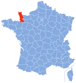
| Manche | |
| Lower Franconia, Bavaria | |
| Amt Neuhaus, District of Lüneburg, Lower Saxony | |
| Osnabrück District and City, Lower Saxony | |
| Altenburger Land, Thuringia | |
| Southeastern Mureș County | |
| Southeastern Győr-Moson-Sopron County | |
| Northern Pest County | |
| Clonlisk, County Offaly | |
| Tullyhaw, County Cavan | |
| Province of Rieti, Lazio | |
| Raseiniai District Municipality, Kaunas County | |
| Dieveniškės, Vilnius County | |
| Rivierenland, Gelderland | |
| Steenwijkerland, Overijssel | |
| Viken | |
| Wschowa County, Lubusz Voivodeship | |
| Mourão, Évora District | |
| Mozdoksky District, North Ossetia–Alania | |
| Priyutnensky, Yashaltinsky, and Gorodovikovsky Districts, Kalmykia | |
| Western Chelyabinsk Oblast[c] | |
| Oparinsky, Podosinovsky, and Luzsky Districts, Kirov Oblast | |
| Vorkuta District, Komi Republic | |
| Negueira de Muñiz, Galicia (Spain) | |
| Aranjuez, Madrid (Spain) | |
| A Mezquita, Galicia | |
| Diessenhofen, Schlatt bei Diessenhofen, and Basadingen-Schlattingen, Frauenfeld District, Thurgau | |
| Monthey District, Valais | |
| Buckfastleigh, Teignbridge | |
| Ceiriog Valley, Wrexham County Borough, Wales | |
| English Maelor, Wrexham County Borough, Wales | |
| Western New Forest District, Hampshire | |
| Newmarket, Suffolk | |
| North Cornwall, Cornwall | |
| Stamford, Lincolnshire | |
| South Staffordshire, Staffordshire | |
| The area around Tring, Hertfordshire, which is itself bounded on one side by a salient of Buckinghamshire in the area around Pitstone, Ivinghoe and Dagnall | |
| Ljig, Kolubara District | |
| Ljubovija, Mačva District | |
| Bosnian-Podrinje Canton Goražde, Federation of Bosnia and Herzegovina | |
| Petrovo, Republika Srpska | |
| Ravno, Herzegovina-Neretva Canton |
Oceania

| Salient | Country |
|---|---|
| Northeastern Nadroga-Navosa Province, Western Division | |
| Southern Anetan District | |
| Rangitaiki River Valley, Bay of Plenty Region | |
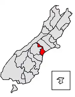
| Hunter River Valley, Otago region | |
| Upper Rangitata Valley, Timaru District | |
| Upper Waitaki Valley, Waitaki District | |
| Northeastern West New Britain Province |
See also
- Bootheel
- Border irregularities of the United States
- Border
- Chicken's Neck (disambiguation)
- Corridor (disambiguation)
- Enclave and exclave
- Fergana Valley (triple junction of Uzbekistan, Kyrgyzstan and Tajikistan)
- Gerrymandering
- Political geography
- Salients, re-entrants and pockets
- The Thumb
Notes
- ↑ This definition includes the following counties: Bay, Calhoun, Escambia, Franklin, Gadsden, Gulf, Holmes, Jackson, Jefferson, Leon, Liberty, Madison, Okaloosa, Santa Rosa, Taylor, Wakulla, Walton, and Washington.
- ↑ This definition includes the following counties: Allegany, Frederick, Garrett, and Washington
- ↑ Encompassing, in order of increasing distance from the main body of the oblast, Kusinsky District, Zlatoust Urban Okrug, Satkinsky District, Tryokhgorny Urban Okrug, Katav-Ivanovsky District, Ust-Katav Urban Okrug and Ashinsky District.
References
- 1 2 Jacobs, Frank (December 5, 2011). "A Few Salient Points". New York Times.
- ↑ Lowitt, Richard (2006). American Outback: The Oklahoma Panhandle in the Twentieth Century. Texas Tech University Press. pp. xvii, xviii. ISBN 9780896725584.
- ↑ Weigert, Hans W. (1957). Principles of Political Geography. New York City: Appleton-Century-Crofts. pp. 73–75.
- ↑ Hubbard, Bill (2008). "Chapter Five: The Evolution of the Territories and States". American Boundaries: The Nation, the States, the Rectangular Survey. University of Chicago Press. p. 167. ISBN 9780226355931.
- ↑ Sautman, Barry (2006). "Tibet and the (Mis)-Representation of Cultural Genocide". In Sautman, Barry (ed.). Cultural Genocide and Asian State Peripheries. New York City: Palgrave Macmillan. p. 207. ISBN 1403975744.
- ↑ Mellor, Roy E. H. (1989). National, State and Territory: A Political Geography. London: Routledge. p. 70. ISBN 9780415022873.
- ↑ Pounds, Norman John Greville (1972). Political geography (2nd ed.). New York City: McGraw-Hill (published 1963). p. 271. ISBN 9780070505667.
- ↑ Ali Tayyeb (1966). Pakistan; A Political Geography. London: Oxford University Press. p. 89.
- ↑ "San Isidro". Google Maps. Google LLC. Retrieved 14 January 2020.
Further reading
- Robert Reid (4 April 2016). "America's Panhandles, Ranked From 1 to 10". National Geographic. Retrieved 2019-05-16.