New South Wales North Coast
| New South Wales North Coast New South Wales | |||||||||||||||
|---|---|---|---|---|---|---|---|---|---|---|---|---|---|---|---|
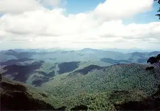 View east over the NSW North Coast towards the Tasman Sea overlooking the Bellinger River valley. | |||||||||||||||
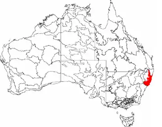 The interim Australian bioregions, with New South Wales North Coast in red. | |||||||||||||||
| Area | 39,966 km2 (15,431.0 sq mi) | ||||||||||||||
| LGA(s) | Bellingen, Clarence Valley, Coffs Harbour, Kempsey, Mid-Coast, Nambucca Valley, Port Macquarie-Hastings, Richmond Valley | ||||||||||||||
| State electorate(s) | Ballina, Clarence, Coffs Harbour, Myall Lakes, Oxley, Port Macquarie, Tweed | ||||||||||||||
| Federal division(s) | Cowper, Lyne, Page, Richmond | ||||||||||||||
| |||||||||||||||
New South Wales North Coast or NSW North Coast, an interim Australian bioregion, is located in New South Wales,[1][2] comprising 3,996,591 hectares (9,875,790 acres).[3]
Subregions
In the IBRA system it has the code of (NNC), and it has nineteen sub-regions:
| IBRA regions and subregions: IBRA7 | ||||
|---|---|---|---|---|
| IBRA subregion | IBRA code | Area | ||
| ha | acres | |||
| Washpool | NNC01 | 59,377 | 146,720 | |
| Cataract | NNC02 | 121,338 | 299,830 | |
| Dalmorton | NNC03 | 316,458 | 781,980 | |
| Chaelundi | NNC04 | 188,279 | 465,250 | |
| Yuraygir | NNC05 | 45,815 | 113,210 | |
| Coffs Coast and Escarpment | NNC06 | 308,115 | 761,370 | |
| Macleay Hastings | NNC07 | 729,170 | 1,801,800 | |
| Carrai Plateau | NNC08 | 20,100 | 50,000 | |
| Macleay Gorges | NNC09 | 153,349 | 378,930 | |
| Upper Manning | NNC10 | 83,181 | 205,540 | |
| Comboyne Plateau | NNC11 | 123,315 | 304,720 | |
| Mummel Escarpment | NNC12 | 400,916 | 990,690 | |
| Barrington | NNC13 | 110,903 | 274,050 | |
| Tomalla | NNC14 | 227,615 | 562,450 | |
| Ellerston | NNC15 | 113,183 | 279,680 | |
| Upper Hunter | NNC16 | 232,750 | 575,100 | |
| Karuah Manning | NNC17 | 602,423 | 1,488,620 | |
| Rocky River Gorge | NNC18 | 86,829 | 214,560 | |
| Guy Fawkes | NNC19 | 73,477 | 181,570 | |
References
- ↑ Environment Australia. "Revision of the Interim Biogeographic Regionalisation for Australia (IBRA) and Development of Version 5.1 – Summary Report". Department of the Environment and Water Resources, Australian Government. Archived from the original on 5 September 2006. Retrieved 31 January 2007.
- ↑ IBRA Version 6.1 data
- ↑ "Interim Biogeographic Regionalisation for Australia (IBRA7) regions and codes". Department of Sustainability, Environment, Water, Population and Communities. Commonwealth of Australia. 2012. Retrieved 13 January 2013.
Further reading
- Thackway, R and I D Cresswell (1995) An interim biogeographic regionalisation for Australia : a framework for setting priorities in the National Reserves System Cooperative Program Version 4.0 Canberra : Australian Nature Conservation Agency, Reserve Systems Unit, 1995. ISBN 0-642-21371-2
This article is issued from Wikipedia. The text is licensed under Creative Commons - Attribution - Sharealike. Additional terms may apply for the media files.