List of mountain peaks of Central America
| Part of a series on |
| Central America |
|---|
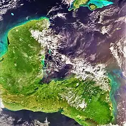 |
Article comprises three sortable tables of major mountain peaks[1] of Central America. This article defines Central America as the seven nations of Belize, Costa Rica, El Salvador, Guatemala, Honduras, Nicaragua, and Panama.
The summit of a mountain or hill may be measured in three principal ways:
- The topographic elevation of a summit measures the height of the summit above a geodetic sea level.[2] The first table below ranks the 25 highest major summits of Central America by elevation.
- The topographic prominence of a summit is a measure of how high the summit rises above its surroundings.[3][2] The second table below ranks the 25 most prominent summits of Central America.
- The topographic isolation (or radius of dominance) of a summit measures how far the summit lies from its nearest point of equal elevation.[4] The third table below ranks the 25 most isolated major summits of Central America.
Highest major summits
Of the 25 highest major summits of Central America, Volcán Tajumulco and Volcán Tacaná exceed 4000 meters (13,123 feet) elevation, 11 peaks exceed 3000 meters (9843 feet), and 24 peaks exceed 2000 meters (6562 feet) elevation.
Of these 25 peaks, nine are located in Honduras, eight in Guatemala, four in El Salvador, three in Costa Rica, two in Panama, and one in Nicaragua. Volcán Tacaná lies on the Guatemala-Mexico border, Cerro El Pital lies on the El Salvador-Honduras border, and Pico Mogotón lies on the Nicaragua-Honduras border.
| Rank | Mountain peak | Country | Mountain range | Elevation | Prominence | Isolation | Location |
|---|---|---|---|---|---|---|---|
| 1 | Volcán Tajumulco[5][a][b] | Sierra de las Nubes | 4220 m 13,845 ft | 3990 m 13,091 ft | 722 km 448 mi |
15°02′35″N 91°54′13″W / 15.0430°N 91.9037°W | |
| 2 | Volcán Tacaná[6][7][c] | Sierra de Istatan | 4067 m 13,343 ft | 1037 m 3,402 ft | 24.1 km 14.99 mi |
15°07′56″N 92°06′30″W / 15.1323°N 92.1084°W | |
| 3 | Volcán Acatenango[8][d] | Chimaltenango | 3975 m 13,041 ft | 1835 m 6,020 ft | 125.9 km 78.2 mi |
14°30′06″N 90°52′32″W / 14.5016°N 90.8755°W | |
| 4 | Alto Cuchumatanes[9][e] | Huehuetenango | 3837 m 12,589 ft | 1877 m 6,158 ft | 65.2 km 40.5 mi |
15°31′06″N 91°32′40″W / 15.5182°N 91.5445°W | |
| 5 | Chirripó Grande[10][f][g] (Cerro Chirripó) |
Cordillera de Talamanca | 3819 m 12,530 ft | 3755 m 12,320 ft | 878 km 546 mi |
9°29′03″N 83°29′20″W / 9.4843°N 83.4889°W | |
| 6 | Volcán Santa María[11] | Sierra Madre | 3772 m 12,375 ft | 1054 m 3,458 ft | 49.4 km 30.7 mi |
14°45′25″N 91°33′06″W / 14.7570°N 91.5517°W | |
| 7 | Volcán de Agua[12] | Escuintla | 3761 m 12,339 ft | 1981 m 6,499 ft | 14.86 km 9.23 mi |
14°27′55″N 90°44′34″W / 14.4654°N 90.7428°W | |
| 8 | Volcán Atitlán[13] | Sierra Madre de Chiapas | 3537 m 11,604 ft | 1754 m 5,755 ft | 33.2 km 20.6 mi |
14°35′00″N 91°11′11″W / 14.5834°N 91.1864°W | |
| 9 | Montañas Peña Blanca[14] | Sierra Madre de Chiapas | 3518 m 11,542 ft | 1858 m 6,096 ft | 39.8 km 24.7 mi |
15°29′59″N 91°54′54″W / 15.4996°N 91.9151°W | |
| 10 | Volcán Barú[15][h][i] | Cordillera de Talamanca | 3474 m 11,398 ft | 1324 m 4,344 ft | 74.2 km 46.1 mi |
8°48′32″N 82°32′34″W / 8.8088°N 82.5427°W | |
| 11 | Volcán Irazú[16] | Cordillera Central, Costa Rica | 3432 m 11,260 ft | 1897 m 6,224 ft | 47.8 km 29.7 mi |
9°58′35″N 83°51′12″W / 9.9764°N 83.8534°W | |
| 12 | Cerro Las Minas[17][j] | Sierra de las Nubes | 2849 m 9,347 ft | 2069 m 6,788 ft | 132 km 82 mi |
14°32′02″N 88°40′49″W / 14.5340°N 88.6804°W | |
| 13 | Montaña de Santa Bárbara[18] | Santa Bárbara | 2744 m 9,003 ft | 2084 m 6,837 ft | 74 km 46 mi |
14°54′49″N 88°06′52″W / 14.9137°N 88.1145°W | |
| 14 | Cerro El Pital[19][k] | Sierra de las Nubes | 2730 m 8,957 ft | 1530 m 5,020 ft | 51.1 km 31.8 mi |
14°23′04″N 89°07′45″W / 14.3844°N 89.1292°W | |
| 15 | Pico Bonito[20][l] | Cordillera Nombre de Dios | 2450 m 8,038 ft | 1710 m 5,610 ft | 151 km 93.8 mi |
15°33′27″N 86°52′32″W / 15.5575°N 86.8756°W | |
| 16 | Montaña los Comayagua[21] | Comayagua | 2407 m 7,897 ft | 1507 m 4,944 ft | 80.1 km 49.7 mi |
14°30′00″N 87°30′00″W / 14.5000°N 87.5000°W | |
| 17 | Volcán de Santa Ana[22] | Sierra Madre de Chiapas | 2362 m 7,749 ft | 1602 m 5,256 ft | 69.1 km 42.9 mi |
13°51′21″N 89°37′44″W / 13.8557°N 89.6288°W | |
| 18 | Sierra de Agalta high point[23] | Sierra de Agalta | 2335 m 7,661 ft | 1505 m 4,938 ft | 122.6 km 76.1 mi |
14°57′27″N 85°54′59″W / 14.9576°N 85.9165°W | |
| 19 | Pico Pijol[24] | Yoro | 2320 m 7,612 ft | 1578 m 5,177 ft | 65.1 km 40.4 mi |
15°11′00″N 87°34′00″W / 15.1833°N 87.5667°W | |
| 20 | Montaña San Ildefonso[25] | Cortés | 2242 m 7,356 ft | 1702 m 5,584 ft | 68.6 km 42.7 mi |
15°31′00″N 88°14′00″W / 15.5167°N 88.2333°W | |
| 21 | Volcán de San Vicente[26] | Sierra Madre de Chiapas | 2182 m 7,159 ft | 1562 m 5,125 ft | 90.3 km 56.1 mi |
13°35′47″N 88°50′15″W / 13.5965°N 88.8376°W | |
| 22 | Volcán San Miguel[27] | Sierra Madre de Chiapas | 2131 m 6,991 ft | 1831 m 6,007 ft | 64.1 km 39.8 mi |
13°26′05″N 88°16′09″W / 13.4348°N 88.2691°W | |
| 23 | Pico Mogotón[28][m] | Sierra de las Nubes | 2106 m 6,909 ft | 1321 m 4,334 ft | 142 km 88.2 mi |
13°45′47″N 86°23′54″W / 13.7631°N 86.3983°W | |
| 24 | Volcán Miravalles[29] | Cordillera de Guanacaste | 2028 m 6,654 ft | 1528 m 5,013 ft | 99.4 km 61.8 mi |
10°44′49″N 85°09′02″W / 10.7469°N 85.1505°W | |
| 25 | Cerro Tacarcuna[30][n] | Darién | 1875 m 6,152 ft | 1770 m 5,807 ft | 174.4 km 108.3 mi |
8°09′57″N 77°17′45″W / 8.1659°N 77.2959°W |
Most prominent summits
Of the 25 most prominent summits of Central America, Volcán Tajumulco and Chirripó Grande exceed 3000 meters (9843 feet) of topographic prominence, four peaks exceed 2000 meters (6562 feet), and 23 peaks are ultra-prominent summits with at least 1500 meters (4921 feet) of topographic prominence.
Of these 25 peaks, eight are located in Honduras, five in Guatemala, four in El Salvador, three in Costa Rica, three in Nicaragua, and two in Panama. Cerro El Pital lies on the El Salvador-Honduras border and Pico Mogotón lies on the Nicaragua-Honduras border.
| Rank | Mountain peak | Country | Mountain range | Elevation | Prominence | Isolation | Location |
|---|---|---|---|---|---|---|---|
| 1 | Volcán Tajumulco[5][a][b] | Sierra de las Nubes | 4220 m 13,845 ft | 3990 m 13,091 ft | 722 km 448 mi |
15°02′35″N 91°54′13″W / 15.0430°N 91.9037°W | |
| 2 | Chirripó Grande[10][f][g] (Cerro Chirripó) |
Cordillera de Talamanca | 3819 m 12,530 ft | 3755 m 12,320 ft | 878 km 546 mi |
9°29′03″N 83°29′20″W / 9.4843°N 83.4889°W | |
| 3 | Montaña de Santa Bárbara[18] | Santa Bárbara | 2744 m 9,003 ft | 2084 m 6,837 ft | 74 km 46 mi |
14°54′49″N 88°06′52″W / 14.9137°N 88.1145°W | |
| 4 | Cerro Las Minas[17][j] | Sierra de las Nubes | 2849 m 9,347 ft | 2069 m 6,788 ft | 132 km 82 mi |
14°32′02″N 88°40′49″W / 14.5340°N 88.6804°W | |
| 5 | Volcán de Agua[12] | Escuintla | 3761 m 12,339 ft | 1981 m 6,499 ft | 14.86 km 9.23 mi |
14°27′55″N 90°44′34″W / 14.4654°N 90.7428°W | |
| 6 | Volcán Irazú[16] | Cordillera Central, Costa Rica | 3432 m 11,260 ft | 1897 m 6,224 ft | 47.8 km 29.7 mi |
9°58′35″N 83°51′12″W / 9.9764°N 83.8534°W | |
| 7 | Alto Cuchumatanes[9][e] | Huehuetenango | 3837 m 12,589 ft | 1877 m 6,158 ft | 65.2 km 40.5 mi |
15°31′06″N 91°32′40″W / 15.5182°N 91.5445°W | |
| 8 | Montañas Peña Blanca[14] | Sierra Madre de Chiapas | 3518 m 11,542 ft | 1858 m 6,096 ft | 39.8 km 24.7 mi |
15°29′59″N 91°54′54″W / 15.4996°N 91.9151°W | |
| 9 | Volcán Acatenango[8][d] | Chimaltenango | 3975 m 13,041 ft | 1835 m 6,020 ft | 125.9 km 78.2 mi |
14°30′06″N 90°52′32″W / 14.5016°N 90.8755°W | |
| 10 | Volcán San Miguel[27] | Sierra Madre de Chiapas | 2131 m 6,991 ft | 1831 m 6,007 ft | 64.1 km 39.8 mi |
13°26′05″N 88°16′09″W / 13.4348°N 88.2691°W | |
| 11 | Cerro Tacarcuna[30][n] | Darién | 1875 m 6,152 ft | 1770 m 5,807 ft | 174.4 km 108.3 mi |
8°09′57″N 77°17′45″W / 8.1659°N 77.2959°W | |
| 12 | Volcán Atitlán[13] | Sierra Madre de Chiapas | 3537 m 11,604 ft | 1754 m 5,755 ft | 33.2 km 20.6 mi |
14°35′00″N 91°11′11″W / 14.5834°N 91.1864°W | |
| 13 | Pico Bonito[20][l] | Cordillera Nombre de Dios | 2450 m 8,038 ft | 1710 m 5,610 ft | 151 km 93.8 mi |
15°33′27″N 86°52′32″W / 15.5575°N 86.8756°W | |
| 14 | Montaña San Ildefonso[25] | Cortés | 2242 m 7,356 ft | 1702 m 5,584 ft | 68.6 km 42.7 mi |
15°31′00″N 88°14′00″W / 15.5167°N 88.2333°W | |
| 15 | Volcán San Cristóbal[31] | Cordillera Los Maribios | 1745 m 5,725 ft | 1665 m 5,463 ft | 134.5 km 83.6 mi |
12°42′09″N 87°00′21″W / 12.7026°N 87.0057°W | |
| 16 | Volcán de Santa Ana[22] | Sierra Madre de Chiapas | 2362 m 7,749 ft | 1602 m 5,256 ft | 69.1 km 42.9 mi |
13°51′21″N 89°37′44″W / 13.8557°N 89.6288°W | |
| 17 | Volcán Concepción[32] | Rivas | 1610 m 5,282 ft | 1579 m 5,180 ft | 69.6 km 43.3 mi |
11°32′17″N 85°37′21″W / 11.5380°N 85.6226°W | |
| 18 | Pico Pijol[24] | Yoro | 2320 m 7,612 ft | 1578 m 5,177 ft | 65.1 km 40.4 mi |
15°11′00″N 87°34′00″W / 15.1833°N 87.5667°W | |
| 19 | Volcán de San Vicente[26] | Sierra Madre de Chiapas | 2182 m 7,159 ft | 1562 m 5,125 ft | 90.3 km 56.1 mi |
13°35′47″N 88°50′15″W / 13.5965°N 88.8376°W | |
| 20 | Cerro El Pital[19][k] | Sierra de las Nubes | 2730 m 8,957 ft | 1530 m 5,020 ft | 51.1 km 31.8 mi |
14°23′04″N 89°07′45″W / 14.3844°N 89.1292°W | |
| 21 | Volcán Miravalles[29] | Cordillera de Guanacaste | 2028 m 6,654 ft | 1528 m 5,013 ft | 99.4 km 61.8 mi |
10°44′49″N 85°09′02″W / 10.7469°N 85.1505°W | |
| 22 | Montaña los Comayagua[21] | Comayagua | 2407 m 7,897 ft | 1507 m 4,944 ft | 80.1 km 49.7 mi |
14°30′00″N 87°30′00″W / 14.5000°N 87.5000°W | |
| 23 | Sierra de Agalta high point[23] | Sierra de Agalta | 2335 m 7,661 ft | 1505 m 4,938 ft | 122.6 km 76.1 mi |
14°57′27″N 85°54′59″W / 14.9576°N 85.9165°W | |
| 24 | Volcán Barú[15][h][i] | Chiriquí | 3474 m 11,398 ft | 1324 m 4,344 ft | 74.2 km 46.1 mi |
8°48′32″N 82°32′34″W / 8.8088°N 82.5427°W | |
| 25 | Pico Mogotón[28][m] | Sierra de las Nubes | 2106 m 6,909 ft | 1321 m 4,334 ft | 142 km 88.2 mi |
13°45′47″N 86°23′54″W / 13.7631°N 86.3983°W |
Most isolated major summits
Of the 25 most isolated major summits of Central America, Chirripó Grande and Volcán Tajumulco exceed 500 kilometers (310.7 miles) of topographic isolation and 11 peaks exceed 100 kilometers (62.14 miles) of topographic isolation.
Of these 25 peaks, nine are located in Honduras, four in Guatemala, four in El Salvador, three in Panama, three in Nicaragua, three in Costa Rica, and one in Belize. Pico Mogotón lies on the Nicaragua-Honduras border and Cerro El Pital lies on the El Salvador-Honduras border.
| Rank | Mountain peak | Country | Mountain range | Elevation | Prominence | Isolation | Location |
|---|---|---|---|---|---|---|---|
| 1 | Chirripó Grande[10][f][g] (Cerro Chirripó) |
Cordillera de Talamanca | 3819 m 12,530 ft | 3755 m 12,320 ft | 878 km 546 mi |
9°29′03″N 83°29′20″W / 9.4843°N 83.4889°W | |
| 2 | Volcán Tajumulco[5][a][b] | Sierra de las Nubes | 4220 m 13,845 ft | 3990 m 13,091 ft | 722 km 448 mi |
15°02′35″N 91°54′13″W / 15.0430°N 91.9037°W | |
| 3 | Cerro Tacarcuna[30][n] | Darién | 1875 m 6,152 ft | 1770 m 5,807 ft | 174.4 km 108.3 mi |
8°09′57″N 77°17′45″W / 8.1659°N 77.2959°W | |
| 4 | Pico Bonito[20][l] | Cordillera Nombre de Dios | 2450 m 8,038 ft | 1710 m 5,610 ft | 151 km 93.8 mi |
15°33′27″N 86°52′32″W / 15.5575°N 86.8756°W | |
| 5 | Pico Mogotón[28][m] | Sierra de las Nubes | 2106 m 6,909 ft | 1321 m 4,334 ft | 142 km 88.2 mi |
13°45′47″N 86°23′54″W / 13.7631°N 86.3983°W | |
| 6 | Doyle's Delight[33][o][p] | Yucatán Peninsula | 1174 m 3,852 ft | 500 m 1,640 ft | 138.3 km 85.9 mi |
16°29′39″N 89°02′44″W / 16.4941°N 89.0456°W | |
| 7 | Cerro Hoya[34][q] | Azuero Peninsula | 1559 m 5,115 ft | 500 m 1,640 ft | 135.7 km 84.3 mi |
7°19′04″N 80°40′52″W / 7.3179°N 80.6810°W | |
| 8 | Volcán San Cristóbal[31] | Cordillera Los Maribios | 1745 m 5,725 ft | 1665 m 5,463 ft | 134.5 km 83.6 mi |
12°42′09″N 87°00′21″W / 12.7026°N 87.0057°W | |
| 9 | Cerro Las Minas[17][j] | Sierra de las Nubes | 2849 m 9,347 ft | 2069 m 6,788 ft | 132 km 82 mi |
14°32′02″N 88°40′49″W / 14.5340°N 88.6804°W | |
| 10 | Volcán Acatenango[8][d] | Chimaltenango | 3975 m 13,041 ft | 1835 m 6,020 ft | 125.9 km 78.2 mi |
14°30′06″N 90°52′32″W / 14.5016°N 90.8755°W | |
| 11 | Sierra de Agalta high point[23] | Sierra de Agalta | 2335 m 7,661 ft | 1505 m 4,938 ft | 122.6 km 76.1 mi |
14°57′27″N 85°54′59″W / 14.9576°N 85.9165°W | |
| 12 | Volcán Miravalles[29] | Cordillera de Guanacaste | 2028 m 6,654 ft | 1528 m 5,013 ft | 99.4 km 61.8 mi |
10°44′49″N 85°09′02″W / 10.7469°N 85.1505°W | |
| 13 | Volcán de San Vicente[26] | Sierra Madre de Chiapas | 2182 m 7,159 ft | 1562 m 5,125 ft | 90.3 km 56.1 mi |
13°35′47″N 88°50′15″W / 13.5965°N 88.8376°W | |
| 14 | Montaña los Comayagua[21] | Comayagua | 2407 m 7,897 ft | 1507 m 4,944 ft | 80.1 km 49.7 mi |
14°30′00″N 87°30′00″W / 14.5000°N 87.5000°W | |
| 15 | Volcán Barú[15][h][i] | Chiriquí | 3474 m 11,398 ft | 1324 m 4,344 ft | 74.2 km 46.1 mi |
8°48′32″N 82°32′34″W / 8.8088°N 82.5427°W | |
| 16 | Montaña de Santa Bárbara[18] | Santa Bárbara | 2744 m 9,003 ft | 2084 m 6,837 ft | 74 km 46 mi |
14°54′49″N 88°06′52″W / 14.9137°N 88.1145°W | |
| 17 | Volcán Concepción[32] | Rivas | 1610 m 5,282 ft | 1579 m 5,180 ft | 69.6 km 43.3 mi |
11°32′17″N 85°37′21″W / 11.5380°N 85.6226°W | |
| 18 | Volcán de Santa Ana[22] | Sierra Madre de Chiapas | 2362 m 7,749 ft | 1602 m 5,256 ft | 69.1 km 42.9 mi |
13°51′21″N 89°37′44″W / 13.8557°N 89.6288°W | |
| 19 | Montaña San Ildefonso[25] | Cortés | 2242 m 7,356 ft | 1702 m 5,584 ft | 68.6 km 42.7 mi |
15°31′00″N 88°14′00″W / 15.5167°N 88.2333°W | |
| 20 | Alto Cuchumatanes[9][e] | Huehuetenango | 3837 m 12,589 ft | 1877 m 6,158 ft | 65.2 km 40.5 mi |
15°31′06″N 91°32′40″W / 15.5182°N 91.5445°W | |
| 21 | Pico Pijol[24] | Yoro | 2320 m 7,612 ft | 1578 m 5,177 ft | 65.1 km 40.4 mi |
15°11′00″N 87°34′00″W / 15.1833°N 87.5667°W | |
| 22 | Volcán San Miguel[27] | Sierra Madre de Chiapas | 2131 m 6,991 ft | 1831 m 6,007 ft | 64.1 km 39.8 mi |
13°26′05″N 88°16′09″W / 13.4348°N 88.2691°W | |
| 23 | Cerro El Pital[19][k] | Sierra de las Nubes | 2730 m 8,957 ft | 1530 m 5,020 ft | 51.1 km 31.8 mi |
14°23′04″N 89°07′45″W / 14.3844°N 89.1292°W | |
| 24 | Volcán Santa María[11] | Sierra Madre | 3772 m 12,375 ft | 1054 m 3,458 ft | 49.4 km 30.7 mi |
14°45′25″N 91°33′06″W / 14.7570°N 91.5517°W | |
| 25 | Volcán Irazú[16] | Cordillera Central, Costa Rica | 3432 m 11,260 ft | 1897 m 6,224 ft | 47.8 km 29.7 mi |
9°58′35″N 83°51′12″W / 9.9764°N 83.8534°W |
Gallery
 Volcán Tajumulco is the highest summit of Guatemala and all of Central America.
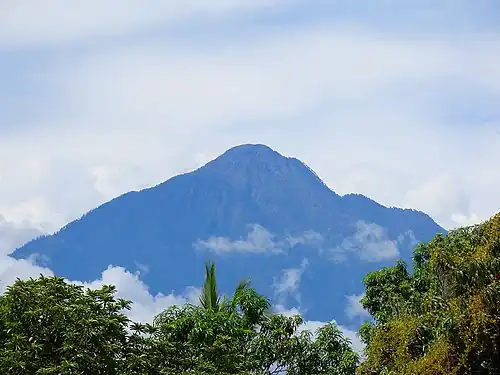 Volcán Tacaná on the border between Guatemala and Mexico is the second highest major summit of Central America.
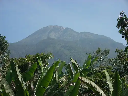
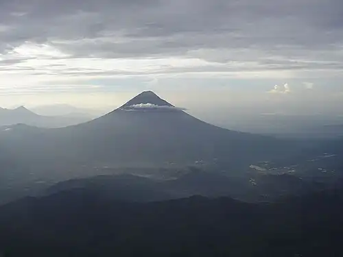 Volcan de Agua in Guatemala.
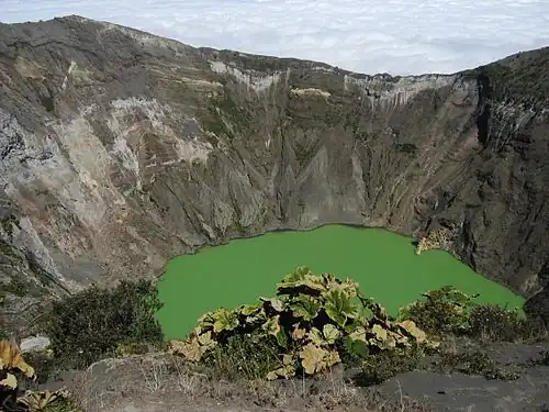 Volcán Irazú in Costa Rica.
See also
- List of mountain peaks of North America
- List of mountain peaks of Greenland
- List of mountain peaks of Canada
- List of mountain peaks of the Rocky Mountains
- List of mountain peaks of the United States
- List of mountain peaks of Mexico
- List of mountain peaks of Central America
- List of the ultra-prominent summits of Central America
- List of extreme summits of Central America
- List of mountain peaks of the Caribbean
- Central America
- Geography of Central America
- Geology of Central America
- Category:Mountains of Central America
- Physical geography
- Topography
- Topographic elevation
- Topographic prominence
- Topographic isolation
- Topography
Notes
- 1 2 3 The summit of Volcán Tajumulco is the highest point of the Sierra de las Nubes, the Republic of Guatemala, and all of Central America.
- 1 2 3 Volcán Tajumulco is the southernmost and easternmost 4000-meter (13,123-foot) summit of greater North America.
- ↑ Volcán Tacaná on the international border with Guatemala is the highest point of Estado Libre y Soberano de Chiapas.
- 1 2 3 Volcán Acatenango is the southernmost and easternmost summit of its elevation in Central America and greater North America.
- 1 2 3 Alto Cuchumatanes is the northernmost 3000-meter (9843-foot) summit of Central America.
- 1 2 3 The summit of Chirripó Grande is the highest point of the Republic of Costa Rica.
- 1 2 3 Chirripó Grande is the southernmost and easternmost summit of its elevation in Central America and greater North America.
- 1 2 3 The summit of Volcán Barú is the highest point of the Republic of Panama.
- 1 2 3 Volcán Barú is the southernmost 3000-meter (9843-foot) summit of Central America and greater North America.
- 1 2 3 The summit of Cerro Las Minas is the highest point of the Republic of Honduras.
- 1 2 3 Cerro El Pital on the international border with Honduras is the highest point of the Republic of El Salvador.
- 1 2 3 Pico Bonito is the northernmost 2000-meter (6562-foot) summit of Central America.
- 1 2 3 Pico Mogotón on the international border with Honduras is the highest point of the Republic of Nicaragua.
- 1 2 3 Cerro Tacarcuna is the southernmost ultra-prominent summit of Central America and greater North America.
- ↑ The summit of Doyle's Delight is the highest point of Belize and the Yucatán Peninsula.
- ↑ Doyle's Delight is the northernmost 1000-meter (3281-foot) summit of Central America.
- ↑ Cerro Hoya is the southernmost 1000-meter (3281-foot) summit of Central America and greater North America.
References
- ↑ This article defines a significant summit as a summit with at least 100 meters (328.1 feet) of topographic prominence, and a major summit as a summit with at least 500 meters (1640 feet) of topographic prominence. All summits in this article have at least 500 meters of topographic prominence. An ultra-prominent summit is a summit with at least 1500 meters (4921 feet) of topographic prominence.
- 1 2 If the elevation or prominence of a summit is calculated as a range of values, the arithmetic mean is shown.
- ↑ The topographic prominence of a summit is the topographic elevation difference between the summit and its highest or key col to a higher summit. The summit may be near its key col or quite far away. The key col for Denali in Alaska is the Isthmus of Rivas in Nicaragua, 7642 kilometers (4749 miles) away.
- ↑ The topographic isolation of a summit is the great-circle distance to its nearest point of equal elevation.
- 1 2 3 "Volcán Tajumulco". Peakbagger.com. Retrieved 5 May 2016.
- ↑ "Volcán Tacaná". Peakbagger.com. Retrieved 5 May 2016.
- ↑ "Volcán Tacaná". Bivouac.com. Retrieved 5 May 2016.
- 1 2 3 "Volcán Acatenango". Peakbagger.com. Retrieved 5 May 2016.
- 1 2 3 "Alto Cuchumatanes". Peakbagger.com. Retrieved 5 May 2016.
- 1 2 3 "Chirripó Grande". Peakbagger.com. Retrieved 5 May 2016.
- 1 2 "Volcán Santa María". Peakbagger.com. Retrieved 5 May 2016.
- 1 2 "Volcán de Agua". Peakbagger.com. Retrieved 5 May 2016.
- 1 2 "Volcán Atitlán". Peakbagger.com. Retrieved 5 May 2016.
- 1 2 "Montañas Peña Blanca". Peakbagger.com. Retrieved 5 May 2016.
- 1 2 3 "Volcán Barú". Peakbagger.com. Retrieved 5 May 2016.
- 1 2 3 "Volcán Irazú". Peakbagger.com. Retrieved 5 May 2016.
- 1 2 3 "Cerro Las Minas". Peakbagger.com. Retrieved 5 May 2016.
- 1 2 3 "Montaña de Santa Bárbara". Peakbagger.com. Retrieved 5 May 2016.
- 1 2 3 "Cerro El Pital". Peakbagger.com. Retrieved 5 May 2016.
- 1 2 3 "Pico Bonito". Peakbagger.com. Retrieved 5 May 2016.
- 1 2 3 "Montaña los Comayagua". Peakbagger.com. Retrieved 5 May 2016.
- 1 2 3 "Volcán de Santa Ana". Peakbagger.com. Retrieved 5 May 2016.
- 1 2 3 "Sierra de Agalta high point". Peakbagger.com. Retrieved 5 May 2016.
- 1 2 3 "Pico Pijol". Peakbagger.com. Retrieved 5 May 2016.
- 1 2 3 "Montaña San Ildefonso". Peakbagger.com. Retrieved 5 May 2016.
- 1 2 3 "Volcán de San Vicente". Peakbagger.com. Retrieved 5 May 2016.
- 1 2 3 "Volcán San Miguel". Peakbagger.com. Retrieved 5 May 2016.
- 1 2 3 "Pico Mogotón". Peakbagger.com. Retrieved 5 May 2016.
- 1 2 3 "Volcán Miravalles". Peakbagger.com. Retrieved 5 May 2016.
- 1 2 3 "Cerro Tacarcuna". Peakbagger.com. Retrieved 5 May 2016.
- 1 2 "Volcán San Cristóbal". Peakbagger.com. Retrieved 5 May 2016.
- 1 2 "Volcán Concepción". Peakbagger.com. Retrieved 5 May 2016.
- ↑ "Doyle's Delight". Peakbagger.com. Retrieved 5 May 2016.
- ↑ "Cerro Hoya". Peakbagger.com. Retrieved 5 May 2016.